
The following is a recollection of an intense two-day drive through the foothills of the Andes Mountains on the Argentinian side. This trip occurred in 2010, well before I had ever fathomed being a travel blogger, and this is my first time putting the story into writing. This post covers just two days out of a 7 day, ~2,500 mile trip in Chile and Argentina. For more, check out these countries on my travel map.
After a frustratingly quick stay in Mendoza, we got up bright and early to find our next destination. Given the trouble we had crossing the border into Argentina a day earlier, we really had no choice but to drive south. With only a map of Chile in hand, we decided that the best course of action would be to take Ruta 40 the entire way until we either ran out of gas, found a hotel or became stranded in the middle of nowhere.
Along the way we saw just about every topography known to mankind, had several near misses when it comes to tire blow-outs, and ended up with a great story to tell.
Day 1: Mendoza to Zapala, Argentina
According to Google Maps our first day through the uninhabited foothills of the Argentinian Andes mountains saw us traveling 897 Kilometers and should have taken us over 11 hours to complete. We probably did it in 9 hours.

There is quite the contrast between the Andes Mountains once you get over the peak. On the Chile side, everything is lush and green as you head up the mountain. You could even go as far as to say that some areas feel like a tropical rainforest right as you cross the border into Chile.
On the Argentina side, it’s dry and there is very little moisture. According to Wikipedia, this is a geographic effect known as a Rain Shadow, and it was prevalent throughout the majority of our drive through the Andes Foothills in Argentina.
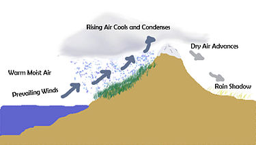
Piecing together the journey today using Google Maps, you can really see what a Rain Shadow looks like in full effect.

So you can imagine what our journey might have looked like as we traveled at a torrid pace through an area with a population density of somewhere around 1 person per square mile. It was equal parts exhilarating, scary and beautiful to fly through a new country with a map of a different country, barely speak the language and not know where to go.
There really were only two certainties we knew for the journey: Ruta 40 was the road that would get us to Patagonia and that we had a spare tire if we needed to use it. Everything else was up for grabs.

Since we didn’t know what we were getting ourselves into, time wasn’t much of an issue. One of our first orders of business was to do a family tradition of starting a camp fire in every new country visited (not my tradition and I was a little concerned about starting a fire, but my uncles are professionals).

Then there was a ton of driving. At the beginning much of the land was flat, and we even saw a few interesting points of interest along the way.

And we made sure to stop for gas and supplies in whatever small town we encountered.

For the most part, the roads were decent, but there was a two hour stretch where I was behind the wheel driving through an area where the road simply disintegrated underneath us. It was as if they had created a road in the 1950’s and then simply decided that they did their deed and never touched it again. If only I had taken pictures of just how bad the road was – it was like a road made out of compressed sand, only with chunks of broken road spiking up all over the place (think vertical chunks of asphalt with pointy edges). Wanting to make pace and make sure that I proved my manliness to my elders, I decided to do what anyone would do in the situation: blaze through this road at 90 KMPH and get us the heck out of there as fast as possible. We always had the spare tire if needed.
Fortunately we did not need the tire and eventually the roads got better. Not long after catching a fully formed road again, we happened along a stream that had carved into deep black volcanic rock. While the photos don’t do the deep obsidian color justice, it was a beautiful sight in person.


Again, by sleuthing my journey together using Google Maps, it appears that the above photos were taken here around an inactive volcano.

Not long after passing the volcano we saw our first oasis in the barren land as we passed a beautiful blue lake with sights clear from the road as we passed by. I hopped out of the car and snapped several photos before continuing on with our journey.


Seeing the lake and the farm that was able to use the lake to irrigate crops was closest that we came to seeing civilization in several hours, and also a sign that our journey may soon be over. I managed to snap one last photo before we found a place to rest for the night.

After driving for countless hours and taking in the beautiful mountainous sights of the Argentinian Andes, we found a town that seemed big enough for us to stop and find lodging for the night. This town is called Zapala and you can read all about the town if you click that link. Let’s just say that it cost about $30 for lodging, food and drink in the town. Great value!
Day 2: Zapala to San Carlos de Bariloche, Argentina

The next day we got up early once again and headed out for the seemingly easy part of our journey – traveling around 4 hours to San Carlos de Bariloche. Our minds were focused on making it into town as early as possible so that we could catch the Minnesota Vikings playoff game on television.

The beginning of the drive was much like what we saw the day before. Mountains, sand and some scrub trees.

About an hour into the drive we noticed something that was impossible to ignore. A giant and beautiful cloud that seemed to follow us for miles. Wanting to get a picture, but not willing to take too long, I snapped several photos of the cloud out of the car window as we drove past it. You may recognize this Spaceship cloud as last Friday’s photo of the week.


I consider the cloud a turning point in this two day voyage, because from there it got to be beautiful. In addition to the mountains we started to see more green life, rift valleys, streams, lakes and more. I’ll let the pictures do the talking.


The drive leading up to San Carlos de Bariloche was simply incredible. While the roads are tightly situated between mountains and lakes, you feel like you don’t want to blink and miss any of the beauty of the area. The lakes are beautifully blue, the mountains are a diverse range of colors and styles, and everything just feels perfect. Perhaps the most unexpected thing to see was all kinds of high end Mercedes Benz cars driving through the mountains near us… but then again, Argentina has a large number of Germans living in the area. No other comment there.


Would I recommend this trip to others?
If you have a death wish, then yes. If you are looking for something a little more tame? I highly recommend that you fly between these locations in Argentina. Bariloche is a city that I want to visit for an extended period of time. One day was not enough. However, since all of the great sights come within an hour of town, save yourself the trouble and just fly there and rent a car.